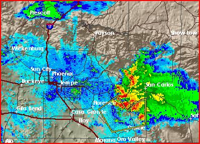
Dude, I am not the weather expert that you seem to be - but when I look at the map, I don't see any storms to the north?? What am I missing??
There were storms up north between New River and Prescott about 2 hours ago that have since dissipated. When they died, they sent out outflow boundaries (just think all the really cool air from the top of the storm rushing down from the top and then spreading out in all directions, which in stronger storms are the big microbursts that cause all the damage.) which are sometimes even visible by radar. If you look at the image that O posted you can actually see the leading edge of this outflow (the darker blue edge out in front of the storms coming from the east). When outflow boundaries collide they cause the air to rise rapidly which in turn helps fuel and create thunderstorms. Think of two waves moving through a pool and when they hit they force each other straight up in the air.
Well the outflows from the storms up north just moved through the valley about 15 min ago so if these storms get close enough that will help enhance storm development and strength.
All those huge monsoon storm nights we usually get occur when outflow boundaries from the storms to the north and the boundaries from the east collide over the metro area allow the storms to continue to build long after the hottest part of the day has passed.


